.JPG)
The weather could not have been more perfect to dig in the dirt and work up a sweat on Saturday, October 5th. We had nearly 20 volunteers ranging from students in several departments across Oregon State University to members of the public who have loyally volunteered before. I even used my tactful persuasion skills to wrangle in a few fellow graduate students in forestry who had never done trail work. A few local residents living adjacent to the tract also showed up to volunteer and essentially contribute to a new recreation outlet in their own backyard (yay!). This short connector trail will link the 580 road that runs through the adjacent McDonald Forest with the Firehouse Trail in the Cameron Tract. The overarching goal of the trail is to provide the public with a more convenient outlet to check out the recent pole sale and to demonstrate how forest vitality, recreation, education and revenue creation can not only exist on the same tract of land, but mutually benefit each other. It's multi-use on a small scale at it's finest! The entire trail is about a third of a mile (1600 feet) long and we succeeded in digging nearly 800 feet of it in one afternoon.
The trail was designed with mountain bikers, hikers and horse back riders all in mind. Isaac Daniels, an instructor in the College of Forestry and trail building extraordinaire provided the brainpower for the trail design. Here is an elevation grid and topo map of the project area (both are courtesy of Dick Oughton) :
 |
| Trail elevation chart |
 |
| Topo map of the project area showing both the new trail and older dispersed trail |
The following photos were taken by me and my advisor John Bliss
 |
| Trail tools |
 |
| It was a wee bit cold! |
 |
| This is the upper section of the trail. |
 |
| Let the digging commence! |
 |
| Moving a log to reinforce the swtich-back near the top |
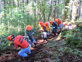 |
| It was truly a team effort! |
 |
| The completed switch-back. Perfect for a hiker or mountain biker! |
 |
| After |
 |
| Before |
 |
Jonathon, a grad student in Forestry shows off
his mad earth moving skills |
 |
Myself and Stacey, another fellow graduate student in
the College of Forestry |

 |
Using a level to make sure the trail is correctly out sloped
to allow for water run-off and prevent rutting |
 |
| Isaac Daniels who headed the trail design effort |
.JPG) |
| John Bliss fueling the trusty chain saw |
 |
Douglas Pereira, the volunteer coordinator for the College Forests
helps to level the trail with a hand compactor |
Thanks again to everyone who volunteered part of their sunny Saturday to make this project happen. Hopefully this trail will be maintained for years to come as a recreation and education opportunity for small woodland owners and the greater community of Corvallis.

.JPG)


.JPG)


.JPG)

No comments:
Post a Comment